Types of Maps
The website includes two main types of maps: Identification maps (ID-maps) and thematic maps.
The ID-maps under the Cultural Units main menu, are documenting all the culture bearing units of the ATLAS. They are organized by regions and countries, allowing to identify each and every point on the thematic maps under Cultural Heritage. Since the ID-maps lead to basic methodological problems of the ATLAS, these are discussed under the same heading.
The thematic maps under the main menu Cultural Heritage present the cultural traits of the units outlined in the ID-maps. There are three types of thematic maps: cultural types, country averages, and local points – see the following overview:
1. Identification maps (ID-maps)
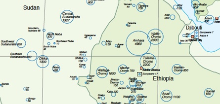
The 2440 cultural units are defined with name and population size (1960) in 12 ID-maps of different regions. In most of the countries at least 95 % of the national population are documented. The cultural units are the carrier of the cultural informations presented in the thematic maps.
Discussion of ID-maps
Overview
2.Thematic maps
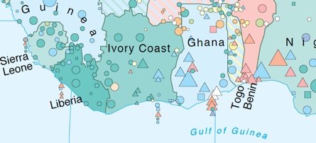
a) Thematic maps I: Cultural types
51 variables of the cultural heritage are visualized on eight thematic maps. These variables are condensed to types of economic, social and political organization. The thematic maps present this information on two levels: (1) the 2440 cultural units and (2) 95 African and Asian countries.
Overview
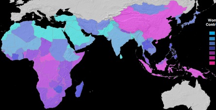
b) Thematic maps II: national averages
These maps show the traditional cultural heritage of 87 African and Asian countries. The symbols indicate the quantitative and standardized country codes of cultural indicators, thereby conveying a so far unreached tableau of the non-European world.
Overview
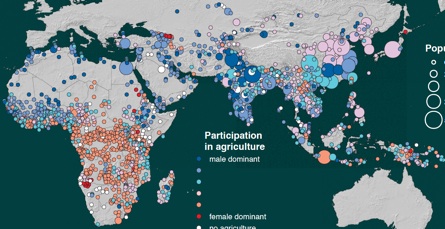
c) Thematic maps III: Local points
Unlike the maps of cultural types, the maps of local points are one-dimensional: First, there is no country signature in the background, second, the points stand for value categories of interval-scaled indices. Compared with the country maps and their national averages, the point maps uncover local differentiations which disappear when national averages alone are mapped. Compare the map on the right with the map above it: both show the same variable.
Overview
Discussion of all thematic maps
Comarison of two maps
Altogether these maps project a detailed view of the diversity of precolonial social structures in Africa, Asia and Melanesia. They raise the question as to what extent structural features of traditional societies are still influencing modern development. The set of maps together with the data bank of cultural indicators are a powerful tool for cross-cultural and cross-national analysis, for teaching sociology or anthropology of development as well as for international experts.