Skip navigation
Header
Logo of the University of Zurich, to homepage
Search
Open/Close Navigation
World Development
Quicklinks
Home
Search
Main navigation
About this website
Zurück
About this website
About this website
Menü schliessen
News
Zurück
News
News
Menü schliessen
Atlas of Pre-Colonial Societies (ATLAS)
Zurück
Atlas of Pre-Colonial Societies (ATLAS)
Atlas of Pre-Colonial Societies (ATLAS)
Menü schliessen
Colonial Transformation Dataset
Zurück
Colonial Transformation Dataset
Colonial Transformation Dataset
Menü schliessen
Research & Publications
Zurück
Research & Publications
Research & Publications
Menü schliessen
Impressum
Zurück
Impressum
Impressum
Menü schliessen
More
Menü schliessen
Home
Atlas of Pre-Colonial Societies (ATLAS)
Cultural Units
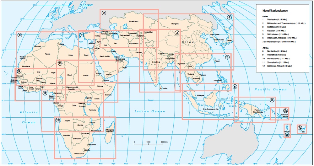
Identification Maps
Identification Maps
12 maps with name and size of 2440 ethnic units in 95 african and asian countries
Source:
Atlas of Pre-Colonial Societies (in German)
Zoom (JPG, 225 KB)
1: West Asia (PDF, 64 KB)
7c: Vanuatu (PDF, 32 KB)
2: Middle Asia and Transcaucasus (PDF, 43 KB)
7d: Fidji (PDF, 32 KB)
3: South Asia (PDF, 67 KB)
8: North Africa (PDF, 46 KB)
4: East Asia (PDF, 41 KB)
9: West Africa (PDF, 45 KB)
5: Southeast Asia (PDF, 41 KB)
10: Northeast Africa (PDF, 40 KB)
6: Indonesia and Malaysia (PDF, 30 KB)
10: Northeast Africa (PDF, 40 KB)
7a: Papua-New Guinea and West Irian (PDF, 32 KB)
11: Central Africa (PDF, 59 KB)
7b: Solomon Islands (PDF, 32 KB)
12: Southern Africa (PDF, 30 KB)
