Subsistence
Type of subsistence economy
The subsistence map shows the spacial distribution of traditional economic regimes. The typology combines two criteria:
- The kind of predominantly produced food (fish, cattle, crops etc.)
- the intensity of agricultural production in combinantion with sedentary lifestyle.
The type of traditional subsistence production tells much about the carrying capacity of the traditional economy. It also raises theoretical issues: What level of population density and social differentiation is possible with a given production system? What are the forces behind more complex production systems and social structures?
Discussion of socio-economic types in the light of cultural evolution (in German) (PDF, 124 KB)
Overlooking the map, the regional difference are striking:
| Blue shades mainly characterize Asia and North Africa. These are areas of old agrarian societies with irrigation technologies. | |
| Green shades mainly signify agricultural systems without irrigation whereby grass-green means intensive (non-irrigated) agriculture, olive-green means extensive agriculture. | |
| Intensive rain-fed farming is typical of northern China and India where there is no irrigation. Other such areas are: Turkey-Levante, Ethiopia, the surroundings of lake Victoria and southern lake of Chad. Extensive agriculture are characteristic of Africa and Melanesia. | |
| Orange-purple is the third colour of significance. It refers to dry areas with different forms of nomadic cattle breeders like e.g. Mongolia. Some countries like Algeria are colored in blue in spite of the dominant desert climate. Such cases reveal the social/cultural – as against physical – quality of the Atlas: The maps visualize cultural features based on the number of people with certain properties. In Algeria, nomadic cattle herders and their descendants are a small minority. Hence the country color (left side of the map legend) is reflecting the demographically dominant subsistence type which is irrigated agriculture. | |
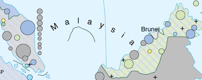
| In cases where no subsistence type reaches 50% or more of the national population, stripes of colors are used to indicate the most important economic forms (bottom-left of the map legend). Usually, more than two colors are not needed to meet the requirements of 50%. | |
Map extract of Malaysia – see map legend above (mixed forms)

Continental A/L: A high proportion (but less than 50%) of irrigated agriculture (A) combined with a high proportion of trade and handicraft (L).
Northern Kalimantan D/A/L: To cover 50% of the population, three subsistence types are needed: Tillage farming (D), irrigated agriculture (A) plus trade and handicraft (L).
For more reading support see area detail of Eastern Africa below and the high information density of the maps:
More about subsistence:
Subsistence Map
Definition of Categories
Discussion of Theories
Comparing with Technology


