Political Organization
Type of political system
The political map presents the distribution of socio-political traits in Africa and Asia. The typology combines two aspects of precolonial social organization:
- The size and number of political levels of the traditional cultural units
- The internal differentiation of societies by wealth and status.
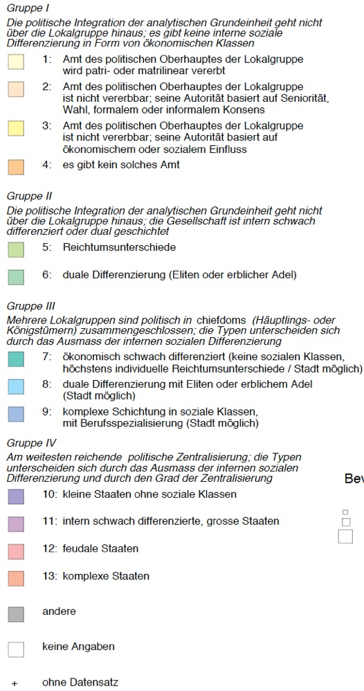
The map legend (below) reveals four main political types, each one with different subtypes. The main criterion of the typology is the level of political centralization. The second criterion is the elaboration of social stratification
Each centralization level is partitioned different degrees and forms of social stratification. In such manner, the typology differentiates between 13 different types of socio-political organization.
More about the definition (PDF, 124 KB)
Variations in terms of size and vertical differentiation of precolonial societies are the strongest single predictor of disparities in the level of modern development. The criteria applied for constructing socio-political types also enter into the definition of the theoretical dimension called Sociopolitial Differentiation.
Discussion of political organization (PDF, 69 KB)
Even a superficial glance at the map reveals significant regional differences. The red color prevails in Asia, North Africa and some small countries (e.g. Ruanda, Burundi, Benin, Yemen). Red is the color of state-like structures in combination with distinct socio-economic differentiation, whereas pink signifies state-like structures with minor internal differentiation (e.g. Nepal, Kazakhstan, Kerala).
| From Saudi Arabia to South Africa, green and blue are the dominant colors. Green symbolizes political structures which hardly transcend local groups, but with significant social stratification; blue points to a situation where several local groups are integrated in chiefdoms and (small) kingdoms of different degrees of social stratification – a common type in subsaharan Africa. | |
| Yellow and ocher denote smallest socio-political differentiation, common in the smallest ethnic units. In no country, people of such cultural heritage form a majority. They are most frequent in Gabon and Papua New Guinea. | |
| The shape of the symbols refer to the size of settlements: -Triangle: precolonial towns present; -Circle: precolonial towns absent; -Square: no information. |
|
| The coding of precolonial political structures often was far from clear. | |
| Usually, the units of analysis in the ATLAS are groups with a common socio-economic lifestyle. However, such groups often are – to varying degrees – integrated in an overarching political structure. In each case, therefore, it had to be decided if the local group should be coded as a politically independent unit or as member of a larger political system, be it colonial (e.g. Philippines), feudal (e.g. Ethiopia), functional (e.g. Arabia) etc. |

Map extract of West Africa:
Besides Ruanda, Burundi, Uganda, Lesotho and Swaziland in the East, West Africa is a further area of sub-Saharan Africa with noteworthy state-like („feudal“) traditions. Most famous in this regard are the Ashanti (primarily in Ghana), the Mossi (Burkina Faso), the Fon and Bariba (Benin), the Yoruba and Ibo (southern Nigeria), the Haussa (northern Nigeria) and the Bamun (western Cameroon). Nearly all cultural units in in red („feudal states“) and many Chiefdoms (blue and green) are marked with triangles, i.e. have some kind of urban settlements.
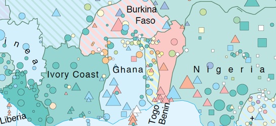
The colors of Togo, Burkina Faso and Mali (top left) are striped. It means that no single political type is represented by 50 % of the national population. Togo is a country where people predominantly descend from small local societies with either limited (yellow) or more prominent (green) internal stratification. In Burkina Faso, the majority stem from societies with traditional state organization, albeit of different types: the Mossi with feudal structures, die Yatenga with small states without stable social classes. Mali is a country where different forms of chiefdoms and small kingdoms dominated.
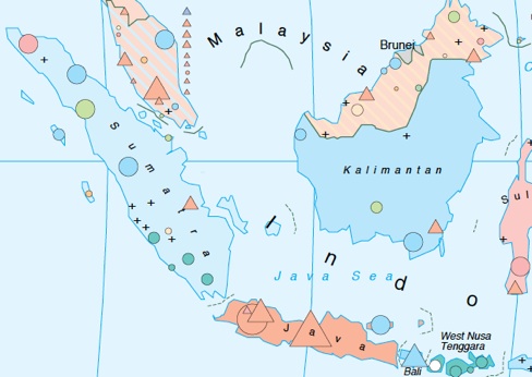
Special features: Indonesia
Due to her special contours and internal heterogeneity, the cultural heritage of Indonesia is covered of eight regions separately. Each region displays an aggregate figure (and color) like it is usually the case for whole countries.
The socio-political conditions of the country are highly heterogenous: Sumatra features „african“ like, Java is rather „asiatic“. As for Kalimantan, the shade is somehow misleading: The blue color results from (southern) Chinese immigrants. They are coded as bearer of an „irrigated agriculture“-tradition, whatever their actual activity. Since they have become a majority by 1960, the descendants of local traditions (green circles) no more can determine the region‘s shade.
The second country geographically determined splitting of the country code is Malaysia. The mainland and North Kalimantan are coded separately. However, the differences between the two regions are not as significant as in Indonesia, and no singly political type is dominant in any region. Brunei – like Singapore a city state with very special conditions and high immigrant population – has not been coded for the ATLAS.